Save as PDF
Washington State Recreation and Conservation Office
Project Snapshot
PRISM Project #08-2025 (Completed)
Touchet River Martin Conservation Easement
    Project Details    
Blue Mountain Land Trust; Touchet River Martin Conservation Easement  (#08-2025)

12/01/2011, Attachment #131079, River 1
Blue Mountain Land Trust; Touchet River Martin Conservation Easement (#08-2025) 12/01/2011, Attachment #131079, River 1

Blue Mountain Land Trust; Touchet River Martin Conservation Easement  (#08-2025)

12/01/2011, Attachment #131079, River 1 Blue Mountain Land Trust; Touchet River Martin Conservation Easement  (#08-2025)

12/01/2011, Attachment #131080, cottonwood galleryBlue Mountain Land Trust; Touchet River Martin Conservation Easement  (#08-2025)

12/01/2011, Attachment #131081, BluffBlue Mountain Land Trust; Touchet River Martin Conservation Easement  (#08-2025)

12/01/2011, Attachment #131082, River 2Blue Mountain Land Trust; Touchet River Martin Conservation Easement  (#08-2025)

12/01/2011, Attachment #131083, River 3Blue Mountain Land Trust; Touchet River Martin Conservation Easement  (#08-2025)

12/01/2011, Attachment #131084, Ag/Riparian Zone BoundaryBlue Mountain Land Trust; Touchet River Martin Conservation Easement  (#08-2025)

12/01/2011, Attachment #131085, Trees
Project Status:  Active Completed since 02/21/2019
Planned Completion:  03/31/2012
Project Type:  Acquisition & Restoration
Project Sponsor:  Blue Mountain Land Trust
Funding Board:  Salmon Recovery Funding Board
              Funding  
Salmon Federal Projects: $224,117
Total RCO Grant: $224,117 (85%)
Sponsor Match: $40,896 (15%)
Total Agreement: $265,013 (100%)
              Links
 

    Project Description    
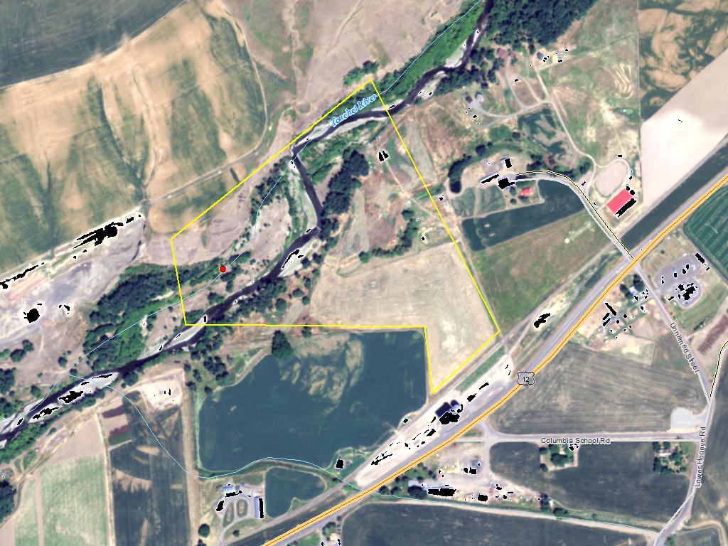
A 43 acre parcel zoned for dense development along the Touchet River 2 miles southwest of Dayton remain vulnerable to development. The landowner would like to consider an easement that would protect approximately 35 acres of floodplain from future development along both sides of the river for ½ mile. This section of river is utilized for steelhead spawning and by bull trout and chinook salmon.

This land is currently zoned AR-1 and could be divided into 1 ½ acre lots. Three adjoining 4 acre lots have alread been created and sold and additional 2 acre lots are being created just east of subject property, demonstrating the development pressure present.

An NRCS fencing project currently prevents livestock access and grazing on the river banks accept where a water gap exists. In addition to removing development and mineral extraction potential within this 35 acre area, the landowner is willing to move the fence location back 75 feet from the river to further protect the bank by prohibiting motorized vehicle use, grazing and other activities that could degrade the riparian habitat values. This will establish two zones within the easement area: an agricultural zone and a riparian zone. Only passive recreational activities and habitat improvements will be allowed within the fenced riparian zone. Outside the fence, agricultural uses will be allowed, but no development.

    Project Contacts    
         
Project Sponsor: Blue Mountain Land Trust Lead Entity: Snake River Salmon Recovery Board Lead Entity
  Project Contact: Amanda Martino
marti@bmlt.org
(509) 525-3136, ext. 1
   
 
Funding Agency: Recreation and Conservation Office    
  Project Manager: Alice Rubin
alice.rubin@rco.wa.gov
(360) 867-8584
   

    Project Location    
General Area:   Touchet River 2 miles southwest of Dayton
Waterbody:   Touchet River, Walla Walla River
County:   Columbia
Legislative District:   09
Congressional District 2022:   05
Salmon Recovery Regions:   Snake River
Watershed Administrative Unit:   Walla Walla Agricultural Lands
HUC8:   Walla Walla (17070102)
WRIA:   Walla Walla
Sections:   02
Township:   T09NR38E
Coordinates:   46.29421223
-118.03227238

    Worksites    
Worksite NameScope of WorkProposed Restoration Cost
Martin (#1) Administrative costs (Acq), Architectural & Engineering (A&E), Cultural resources, Easement, Fencing (C.5.d.1), Riparian Plant removal / control (C.5.h.1), Standard Incidentals, Survey (Acq) $1,325
 Total$1,325
Amounts may not be complete

    Properties    
Worksite Name Property Name Proposed Acquisition
Acres
Proposed Acquisition
Cost
Martin (#1)   Property 1 - Private Landowner 35.00 $370,189
   Total35.00$370,189
Amounts may not be complete

    Project Metrics (Outcomes, Benefits)    
 Category / Work Type / MetricFinal

Restoration Metrics (rolled up from Worksite level)

Riparian Habitat Project
      Fencing (C.5.d.1)
Miles of Fence Along Stream (C.5.d.2) 0.40
Acres of Riparian Area Protected by fencing (C.5.d.3) 1.2

    Project Milestones    
Milestone NameTarget DateDescription
Project Start 01/01/2009
Order Appraisal Review(s) 03/18/2009
Annual Project Billing Due 07/31/2009 and at least once per year thereafter
Annual Project Billing Due 07/31/2010
Progress Report Due 05/31/2011
Purchase Agreement Signed 06/30/2011
Survey Complete 06/30/2011
Special Conditions Met 07/15/2011 Compliance with Governor’s Executive Order 05-05 re: cultural resources consultation
Annual Project Billing Due 07/31/2011
Environmental Clearance Rec'd 08/15/2011
Baseline Docum. Complete 08/15/2011
Acquisition Closing 08/26/2011
Restoration Started 09/01/2011 Fencing and planting
Recorded Acq Documents to RCO 11/01/2011
RCO Final Inspection 12/01/2011
Noxious Weed Control Complete 12/15/2011
Monitor/Steward Plan Submitted 12/15/2011
Restoration Complete 01/31/2012 Fencing and planting complete
Agreement End Date 03/31/2012
Final Docs/Billing to Mgmt Agy 06/30/2012 Re-recorded survey provided October 2012
Final Report Due 06/30/2012

NOTE: This data is subject to change.

    Project Attachments    
Attachment TypeAttachment TitleAttach Date
Agreement - State Agreement.pdf 06/02/2009
Assignment of rights Assignment of Rights - Blue Mountain Land Trust.pdf 11/23/2011
Baseline Inventory Baseline Photos.doc 01/02/2014
Baseline Inventory Martin Baseline addendum signed 2012.pdf 10/24/2012
Baseline Inventory Appendix H Soil Survey.pdf 07/16/2012
Baseline Inventory Martin Baseline Signed.pdf 07/11/2012
Baseline Inventory Martin Boundary Photos.pdf 03/29/2012
Baseline Inventory Martin Baseline Inventory Photos.pdf 03/29/2012
Baseline Inventory Final Martin Baseline Inventory.pdf 03/29/2012
Billing forms Buyer's Statement.pdf 08/11/2011
Correspondence re Martin purchase plan.pdf.pdf 12/23/2020
Correspondence review response.pdf 09/16/2008
Deed or title Title Exceptions.pdf 05/26/2011
Design document Touchet PA MS-14.docx.docx 12/23/2020
Design document Restoration Plan.docx 04/18/2012
Design document (as built) Restoration Plan pdf.pdf 04/18/2012
Easement Martin Signed and Recorded CE.pdf 11/23/2011
Final project report Final Report 10/29/2012.pdf 10/29/2012
Hazardous Substance Certification Form Hazardous Substance Report.pdf 08/15/2011
Inspection Photos Inspection Photos- February 2018.pptx.pptx 12/28/2018
Inspection Report Inspection Report, #1659 (Accepted 12/28/18 17:57:49).pdf 12/28/2018
Inspection Report Inspection Report, #1323 (Accepted 12/28/17 15:14:07).pdf 12/28/2017
Inspection Report 2017 Martin Easement Monitoring Report - signed.pdf 12/28/2017
Landowner acknowledgement form Landowner Acknowledgement Form.pdf 08/29/2008
Map boundary map 081511.doc 08/15/2011
Map vicinity map.ppt 09/15/2008
Map detailed site map.pdf 09/15/2008
Map site plan.pdf 08/29/2008
Monitoring activity Martin Easement Monitoring Visit Report 2018.pdf.pdf 08/09/2018
Monitoring activity Martin Easement Monitoring Visit Report 2016.docx.docx 12/06/2017
Monitoring activity Martin Easement Monitoring Visit Report 2015.docx 01/27/2016
Monitoring activity Martin monitoring report 2014.docx 01/27/2016
Monitoring activity Martin Monitoring Photos 2013.docx 06/17/2013
Monitoring activity Martin monitoring form 2013.doc 06/17/2013
Monitoring activity Martin Monitoring Photos 2012.docx 06/13/2012
Monitoring activity Martin monitoring form 2012.doc 06/13/2012
News Article press release Martin_Conservation_Easement.doc 02/23/2012
News Article News Clip 12/17/08.pdf 03/16/2009
Notice of Long-Term Obligations Blue Mountain Land Trust - July 7, 2015.pdf 07/15/2015
Permit Konen site map with approximate easement boundary.jpg 01/22/2018
Permit Quarry permit application.pdf 01/22/2018
Photo Trees.jpg 01/02/2012
Photo Ag/Riparian Zone Boundary.jpg 01/02/2012
Photo River 3.jpg 01/02/2012
Photo River 2.jpg 01/02/2012
Photo Bluff.jpg 01/02/2012
Photo cottonwood gallery.jpg 01/02/2012
Photo River 1.jpg 01/02/2012
Project presentation property photos.pdf 08/29/2008
Purchase and Sale Agreement 08-2025 c Martin Scan Purchase and Sale Agreement.pdf 08/09/2011
Salmon Project Proposal Project Proposal.pdf 08/29/2008
Salmon Project Proposal 2008 Application.pdf 08/29/2008
Salmon Project Proposal 2008 Pre-Application.pdf 07/11/2008
Salmon Project Proposal Prequalification Worksheet.pdf 06/26/2008
SRFB Review Panel Comment Form 08-2025 Review Panel Comment Form.pdf 07/21/2015
Stewardship plan Signed Stewardship Plan 2012.pdf 07/11/2012
Survey-Property Boundary Martin re-recorded Survey 2012.pdf 10/24/2012
Survey-Property Boundary Martin Recorded Survey 2011.jpg 07/12/2012
Survey-Property Boundary Martin Riparian Fence Survey.pdf 04/18/2012
Visuals Close-out Photos.ppt 01/02/2012

Back to top Date of last change: 03/08/2023